
- Start
- Mining-recultivation, agriculture and cities
- Applied transdisciplinary set of methods
- Literature- and cartographic analysis
- Stakeholder interviews
- Action research
- Description of the research area
- Regional-landscape setting
- Urban situation
- Large and long-established recultivation
- Advantaged but challenged agriculture
- Ongoing fundamental spatial change
- Stakeholder views
- Perception of the current situation
- Expectations for the next 20 years
- Adaption strategies to change
- Insights from pilot activities inspired by action research
- Food Fields
- Food Strip
- Food Hub
- Unique context, disparate value chain and the potential of design concepts
- Towards a new approach?
- About the author(s)
- References
Published 26.04.2023
From Mining-Recultivation Towards Urban Agriculture Strategies
Learning from Informal Planning with Thematic Focus in the Rhenish Mining Area
Keywords: Informal planning; mining recultivation; urban agriculture; regional development; action research
Abstract:
When mining ceases in a region, informal planning dedicated to reorganization can combine recultivation measures with Urban Agriculture (UA) strategies. In this light, this article uses the BMWi-funded project Setup Food Strip in the Rhenish Mining Area in Germany as the base for a case study. Guided by the concept of UA, the aim of the project was to support the strategic development of a multifunctional, diversified and more regionally oriented agri-food sector. This required analytical work as well as design concepts. Findings from mixed methods are reflected upon and address the research question: What are possibilities for informal planning to setup UA strategies in a transforming mining area? Three different dimensions are investigated: (1) regional-landscape setting, (2) stakeholder views and (3) insights from activities of the project inspired by action research. Finally, the article focuses on transferability and directions for further research.
Mining-recultivation, agriculture and cities
Within lignite mining regions, agricultural land losses are generally present. Oftentimes, also recultivation takes place, aiming to restore biological and economical function on landfills after extraction. In the German context, recultivation has been practiced and investigated since the second half of the 19th century. Generally, its basic goal is to re-establish the characteristics of a landscape as they were before extraction (Eyll-Vetter 2009; Pflug 1998). This normally happens in simplified spatial form. In turn this may require advanced planning collaborations in a larger societal context, in which the mining company cooperates at depth with public authorities and other private actors. Already ahead of time, these collaborations facilitate the obligatory return of properties to land users and municipal planning sovereignty in the future. In this article, the Rhenish Mining Area (RMA) in Germany will be used as a reference. Here, advanced recultivation has strived towards new agrarian settlement forms since the 1960’s (Olschowy 1964; Schuhmacher et al. 2011). More recently, it has been planned in coherence with renewable energy infrastructures and even new business parks (Kulik and Voigt 2014).
Both basic and advanced recultivation are practised over decades, in parallel with ongoing mining activities or within a stage when mining already ceases. Particularly the latter case requires new visions and strategies for qualification that address the spatial environment, regional value-creation/jobs and respectively transformative projects (Gärtner 2014; Wirth 2019a, 2019b). Such objectives have to examine different land-uses and pathways, both regarding a sustainable development as well as a region’s own assets and talents.
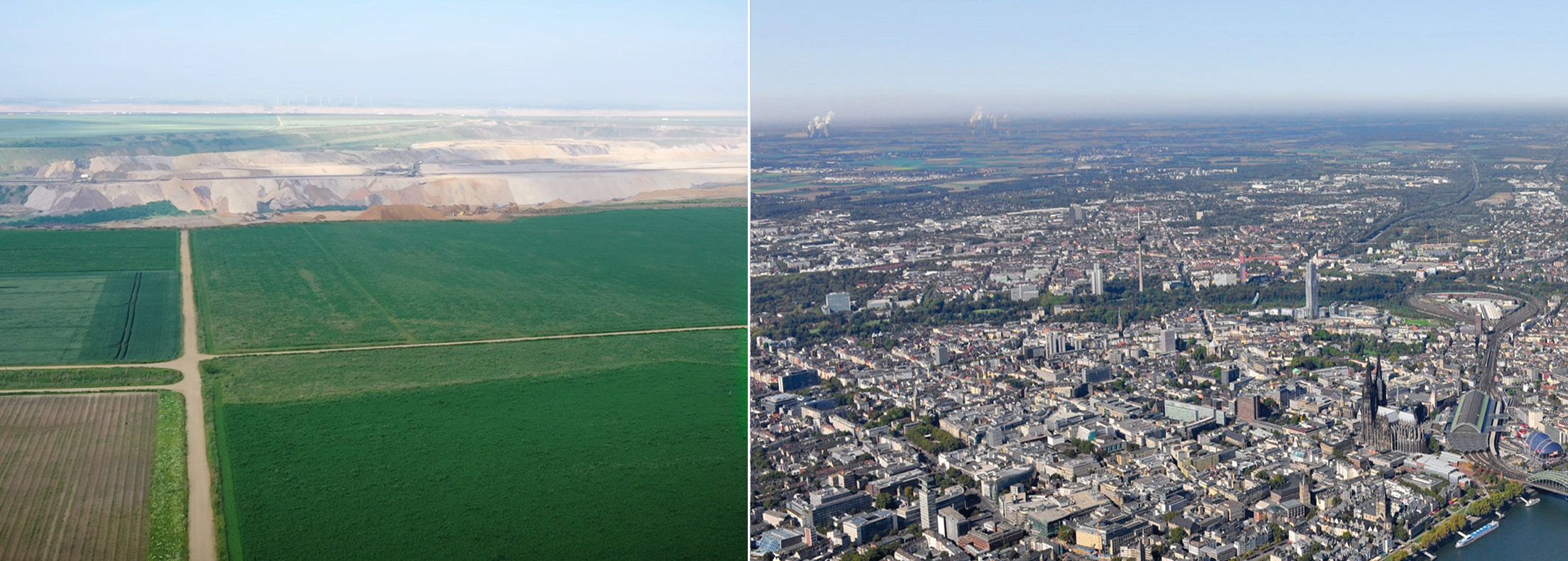
In this respect, agriculture and food can play a major role. For example in the RMA, the agri-food sector allows for ca. 22.400 jobs (compare to circa 10.000 in mining) and creates a yearly revenue of about 7 Billion € (MULNV NRW 2021). Regarding further developments, coal mining areas have oftentimes urban conurbations in their proximity, that function(-ed) as energy consumers. Simultaneously, this also equals the presence of potential food markets with diverse needs and innovation processes (Figure 1). It may even represent an endogenic potential, providing the chance to pursue an ecologically sound and more diverse agrarian development of a post-mining area.
To leverage regional opportunities, recultivation can benefit from an integration into the larger concept of urban agriculture.
Given the global challenges of urbanization, limited resources and food security within the last two decades, urban agriculture (UA) has turned from being a peripheral discipline to a globally recognized mechanism for sustainable development. Milestones in conceptualizing UA have been the work of RUAF Global Partnership on Sustainable Urban Agriculture and Food Systems (2006), the Carrot City initiative (2011) and the achievements of COST Action Urban Agriculture Europe (2016).
UA offers a paradigm shift in spatial planning practices. When it comes to urbanization, so far, agriculture has been often treated as phase-out-model that becomes substituted by new settlements and infrastructure. Urban farmers had a poor lobby and were very much challenged by land loss and a general disesteem of their practice. By way of contrast, the concept of UA focuses on the benefits of agriculture within the regional city, both for citizens and farmers. It is increasingly recognized that agricultural land uses provide diverse ecosystem services to cities, for example in terms of local recreation, biodiversity, climate change adaptation and so on. Also, the farmers can benefit from the urban setting by ways of adapting their businesses to urban needs such as fresh, regional produced food or edutainment services (Lohrberg et al. 2016).
Under the flagship initiative of the Milan Urban Food Policy Pact (MUFPP) many European cities have committed to create regional food chains supplying citizens with healthy and fresh food. Thinking agriculture and food as a regional asset and subject of planning is quite different from the last decades’ policies. Since World War II the food production shifted from local and regional to national and transnational agendas leading to a food providing system much dependent on the world market’s logic and the rules set by the European Union’s Common Agriculture Policies (CAP). However, as shown by the MUFPP in 2015, a renaissance of a more local and regional food thinking is on its way, triggered also by agendas of reducing carbon food prints and safeguarding food supply in (post) pandemic situations.
From a planning perspective, an interplay between UA initiatives and local recultivation measures appears almost universally desirable – given the condition that a transforming mining region has urban conurbations in its vicinity. However, at least in Germany, statutory planning instruments have only limited means to qualify economic value chains and agricultural land use (Fürst 2008: 86). In consequence, informal approaches remain as a potential way forward. Nevertheless, more insights are needed regarding the role of different spatial settings, governance situations and the chances that approaches via pioneering projects may offer.
Therefore, our article investigates the research question: What are possibilities for informal planning to setup UA strategies in a transforming mining area? To address this question, we examine our project Setup Food Strip in the Rhenish Mining Area as a case study.
The project pursued a transdisciplinary approach, since our team combined the knowledge and social practice of landscape architecture, agro-sciences and civil society activism. The aim of Setup Food Strip, funded by the Federal Ministry for Economic Affairs and Energy (BMWi) for less than two years, was to support the strategic development of a multifunctional, diversified and more regionally oriented agri-food sector in the RMA (Wirth 2019c). In parallel, our research activities were meant to enable practitioners within the transdisciplinary interface of the project about an improvement in their own practice (Birley and Moreland 2014: 34). Both attempts required analytical work, conceptual spatial design and pilot actions. In this sense we investigate three different sections in our article: (1) regional-landscape setting, (2) stakeholder views and (3) insights from activities of the project inspired by action research. Our discussion focuses on transferability of the findings and directions for further research and exchange of knowledge.
Applied transdisciplinary set of methods
Our investigation of the RMA corresponds with a single case study based on Simons (2009) and Yin (2013), that investigates the potential interrelations of transformative strategy making, Urban Agriculture and recultivation practice (Healey 2009; Lohrberg et al. 2016; Pflug 1998). Moreover, our project aimed to address problems in a real-world context, which included the need to integrate local and practical knowledge (Levin and Greenwood 2003).
Altogether, this required the collaboration and coproduction of different participants, and thereby mixed methods (Creswell and Plano Clark 2018; Plano Clark and Ivankova 2016). In this sense, our article reports on the following components:
Literature- and cartographic analysis
We thoroughly studied available publications of the study area especially related to economic activities and future prospects of development related to the lignite mining and agricultural production. We used cartographic and economic data on the distribution of agricultural businesses and companies along the value chain to get a concise overview of distribution and clustering of relevant actors along the chain (producers, processors, logistic companies, traders, and retailers) to identify relevant stakeholders. Data on spatial locations was gathered manually by use of online search engines and provisional own knowledge and mapped in a georeferenced way. For larger geographic settings we used various sources that are open access (Geobasis NRW/Basis-DLM) and selected parts by the mining company (RWE Power).
Stakeholder interviews
Based on the cartographic analysis, and subsequently our shared knowledge about individuals and institutions that could be potentially interested in our project, we selected key stakeholders in the research area along the agricultural value chain. We included 18 participants from agricultural production, processing, logistics and marketing. In April and May 2020 we conducted one group discussion and 15 individual interviews and used a video platform for exchange due to the pandemic regulations at the time. We used a predefined set of guiding questions. The questions were targeting already experienced and future expected changes in the area due to the phasing out of lignite production and the planned adaptation strategies of the participating businesses and companies. Due to the low number of interviewees, we could pursue our evaluation based on simple notes and summaries without further systematization.
Action research
Action research describes a practice-oriented way to generate knowledge along steps such as planning, acting, observing and reflecting (Levin and Greenwood 2003). Particularly, we generated design concepts and pursued pilot initiatives that both can be reflected upon. An example for both were our plans and first implementation steps for an innovation area with new cropping practices (see Section on Food Fields).
Action research tries to integrate various available sources of information. In our case, we gathered information via desk research (1) and interviews (2) and frequently discussed it with a special panel of experts that supported the project (six institutions: regional farming association, mining recultivation, regional marketing consortium, three members from (inter-)municipal spatial planning). We also summarized interim outcomes and discussed them with groups of project participants to find out if their information was properly translated into the overall picture.
Description of the research area
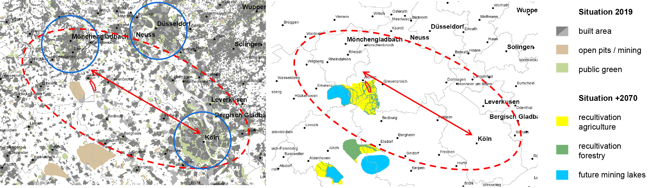
Setup Food Strip focused on the Northeastern part of the lignite mining area in the West of Germany, also known as the Rhenish Mining Area (RMA). The RMA contains Germanys largest open pit mines. While the very central part of the RMA contains small towns and villages surrounding the mines, the RMA is situated right next to Europe’s main corridor of urban development and industrialization, stretching from the UK to Northern Italy, also called the Blue Banana. In Germany this corridor is following the Rhein Valley with its conurbation of Rhein-Ruhr and the metropolitan areas of Aachen, Cologne and Bonn, Düsseldorf and Neuss and Mönchengladbach. For our project we had chosen the B56 federal road as our Food Strip that connects Cologne and Mönchengladbach, thereby comprising parts of the so called Neuland, former mining areas that had been recently recultivated, as well as long-established agricultural land and settlements. This combination within a comparably narrow space between two urban zones appeared as an ideal area for our case study towards the setup of UA strategies.
Regional-landscape setting
To some degree, all lignite mining regions may share similar landscape characteristics, for example by containing power plants and transport infrastructures in either active or defunct form. However, our project Setup Food Strip started with a regional-landscape analysis section that was rather focusing on unique features (Figure 2). This allowed to explore how far the regional-landscape setting provided specific preconditions for building an informal planning strategy towards UA.
Urban situation
A condition already mentioned is the RMA’s metropolitan locations. This appears unique when for example comparing it to the East German Lausitz. The cities surrounding the RMA in the northeast, Cologne and Bonn, Düsseldorf and Neuss and Mönchengladbach, have more than 2 Million inhabitants. Moreover, significant population growth is predicted until the year 2040 (Cicholas and Ströker 2015). This represents the potential for a strong market regarding regional food, with short transport distances and a potential valorization of agriculture in the area. Despite this chance, respective economic structures are still largely missing, apart from weekly markets, direct sales and a few bottom-up initiatives.
Large and long-established recultivation
In the RMA, open pit mining and recultivation is present at quite a large scale. Lignite extraction in this part of Germany has experienced a significant upscaling of mine sizes since the 1920s and WWII (Kleinebeckel 1986). Consequently, newly created land comprises an enormous total area of 210 km², already in 2021. Recultivation in the RMA is also quite long-established. Open pits after extraction have been filled and recultivated already since 1784 (Pflug 1998: 2). This stands for example in contrast to many mining areas in Russia, where recultivation after extraction has not yet been the norm. Recultivation in the RMA follows even a multifunctional approach since the 20st century, thereby also considering biodiversity, recreation and regional value-creation (Eyll-Vetter 2009; Kulik and Voigt 2014). Due to this, for example field experiments for new cropping practises can occasionally be found in the area and become more advanced by projects like Setup Food Strip.
Advantaged but challenged agriculture
Agriculture in the RMA as a whole is on one hand in a favorable position, on the other hand experiencing difficulties. The region is located in the Jülicher Börde – an area which has been utilized for cultivation for over 3000 years. The soils are amongst the most productive and highest quality in the world. This does not only result in positive effects. During the last one hundred years, the modernization of agriculture has brought about fundamental changes here, in other words a concentration on a few large-scale cash crops (sugar beet, cereals), a steady decline in the number of farms (LWK NRW 2016) and quite obviously a simplified landscape with compromised biodiversity. In consequence, there is a need for qualification strategies from both an entrepreneurial as well as a broader societal perspective.
Ongoing fundamental spatial change
The active lignite industry still characterizes major parts of the regional landscape within the RMA. The latter, however, will significantly change. The area is experiencing a transformation process due to climate and energy transition policies since the turn to the 21st century. In response to this, intermunicipal initiatives have emerged, that focus with new spatial visions on the rehabilitation of post-mining areas into park-like landscapes. Over the long term, the situation could change from a backyard situation to a central location, which may also enable farmers and food enterprises to test out new UA concepts, for example by offering high quality local food or by diversifying to provide new offers to local recreation. Overall, we could conclude that the entire setting provided promising conditions for the setup of an UA strategy. For both scholarly and practical reasons, this needed discussions at more depth with stakeholders, which is described in the next chapter.
Stakeholder views
By conducting 15 interviews, with individuals from farming, processing, logistics and marketing, we explored how local stakeholders along the food value chain perceived changes, how they were expecting them and if they were already adapting. In this light, it should be noted that this was conducted in times of a pandemic in April and May 2020. All answers related to recent and expected changes have been influenced by this very special contemporary event and must be understood and read with this lens.
Perception of the current situation
The individual assessments of the current situation, related to ceasing mining and economic change in the region, were different among the stakeholders due to varying a) proximity to an urban center, b) proximity to the active mining zone, c) position in the value chain. Urban based retailers already realized and anticipated a change in the demographics of their customers and successively integrated regionally produced products in their portfolio. Farmers close to the open cast mine reported a shortage of farming land and irrigation water. The logistic sector did not yet experience significant changes and evaluated the loss of agricultural knowledge among all parts of society far more important than structural change in the region. Another interesting comment or even complain on the current situation by most farmers had been the lack of information on structural change and the feeling of uncertainty which was even worsened by the current pandemic. Under pandemic restrictions a lot of direct and coincidental social contacts, for example on village festivals, on market places or during club meetings, did not happen. This had apparently a negative impact on the information status of the farmers.
Expectations for the next 20 years
Most farmers expected the return of agricultural lands from mining to the farming community. Some fears circulated around new expropriations and the loss and degradation of fertile lands. Such threats were seen due to structural change and the potential realization of plans that foster the industrialization of the region, including the setup of huge commercial areas. Most farmers also expected a growth of the urban centers and the creation of residential areas that would contribute to the shortage of farming land. The biggest chance, most stakeholders mentioned, was a renaturation of the entire region and a gain of attractivity which would result in a raise in tourism and reputation. The farmers also expected a rising trend regarding the demand of regionally produced food that could bring up some new forms of (direct) marketing as well as higher revenues. With the rise in tourism, farmers also associated the possibility to present agricultural activities on farm in a more realistic way. Interviewees from the retailing sector also expected a rise and consolidation on a high level of the demand of regional food. They anticipated the creation of innovative logistic solutions that could facilitate the transport of fresh produce from the farming areas to the urban centers.
Adaption strategies to change
Along the value chain we found a plethora of ideas how to adapt to the changing structural conditions in the region. A backbone of all strategies, however, was the intention to foster communication among value chain participants including the potential customers. Many of the farmers already tried experiments with different crops on recultivated as well as traditional lands. They also thought about a structural change in production which would target a more small-scale production that would fit a regionalization and also started to explore new local marketing channels. Some of the farmers invested in diversification towards a multifunctional agriculture that would include recreational and educational offers.
One participant already started the establishment of co-productive forms of agriculture, others thought about including production models that would integrate the working force of customers into agricultural production. The retailing sector was prepared to include more regional products into their shops and platforms. These findings hinted towards different windows of opportunity toward the setup an UA strategy, in which recultivation lands and their processes could work as a potential building block in a larger spatial value-chain context. Hence, we pursued action with three different concepts, which the next chapter describes.
Insights from pilot activities inspired by action research
This section collects insights from the actual process of our project Setup Food Strip that aimed to setup an UA strategy in the RMA. We loosely refer to the concept of action research, a practise-oriented way to investigate along steps such as planning, acting, observing, reflecting. While this is normally pursued in several circles (Levin and Greenwood 2003), we rather look at one only. Planning and acting we started with preliminary design conceptions towards the establishment of a pilot site for new ways of production (Food Fields), followed by mixed-stakeholder workshops. This was pursued simultaneously with a larger regional design concept (Food Strip) and first steps towards multifunctional food distribution centers (Food Hub). Observing and reflecting we pursued in a condensed form, by use of a storyboarding session in which we looked back at the entire process. Practically, this was done along a time trajectory of 1,5 years and assigning relevant notes accordingly. In the following we investigate our three major concepts, each in reference to action research.
Food Fields
The initial planning of our project foresaw to locate, design and implement an innovation area for sustainable cropping practices towards a more regionalized food supply in the RMA – and even to bring startups to such a site. For acting towards these goals, we conducted stakeholder workshops in which we identified sustainability criteria and the desirable spatial characteristics that a potential site should have. The latter included:
- sufficient space
- good soil
- available water
- connection to markets
- proximity to maintenance, processing and logistics sites / infrastructures
- public visibility
- compatibility with existing spatial planning concepts
By observing this and the further process, we could see that we faced difficulties with finding such a manifold site, particularly since land is scarce in the RMA. In this light, we learned that newly emerging land in one of the recultivation areas provided chances. It was managed locally by the mining company RWE Power in a temporary caretaker function. This allowed to bring different farmers with new ideas to the site, for example to grow plant-based protein sources, or power foods such as quinoa. Such crops and their envisaged value chains demonstrated benefits from ecological perspectives, for example towards higher biodiversity or reduced stress on the region’s water budget. Some of these products could be sold in a market in the nearby municipality Jüchen, most products targeted at least regional sales. Generally, the Food Fields site was in line with the idea of UA. The social situation as found, however, required to shift from a pure innovation focus and sustainability criteria towards a broader showcasing of new or unconventional crops. The site was only partially used for testing and instead of detailed sustainability assessments we had to rely on basic information provided by the farmers before introducing them to the site (Figure 3).
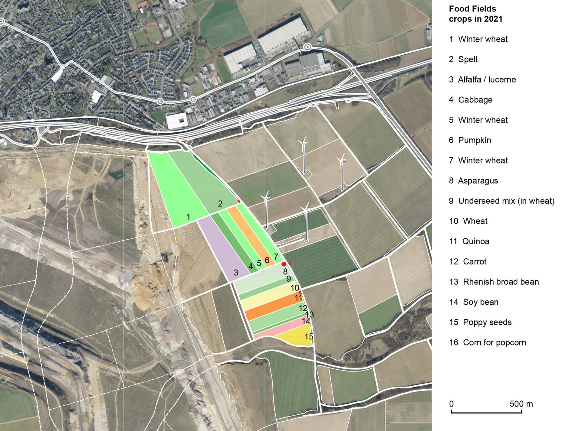
In reflection, we understand that the recultivation area provided an effective starting point for pilot projects towards a diversification of agricultural cropping practice along the idea of UA. Nevertheless, there were limits, due to already established procedures on site, the lack of a critical mass of distinctly innovative actors and of built infrastructures in vicinity. Particularly, this considers our initial orientation towards startups, for whom the area was too remote from the city and lacking financial incentives locally.
Food Strip
The situation found also encouraged us to conceive a regional design (Förster 2020; Kempenaar and van den Brink 2018; Neuman and Zonneveld 2018) dedicated to the UA idea: The Food Strip concept was meant to support innovative actors from agri-food at their different spatial locations (for example farms, greenhouses, markets or research sites) and thereby also integrating recultivation areas. A respective spatial setting could be found in vicinity to the B59, a federal highway between the cities of Cologne and Mönchengladbach (Figure 4).
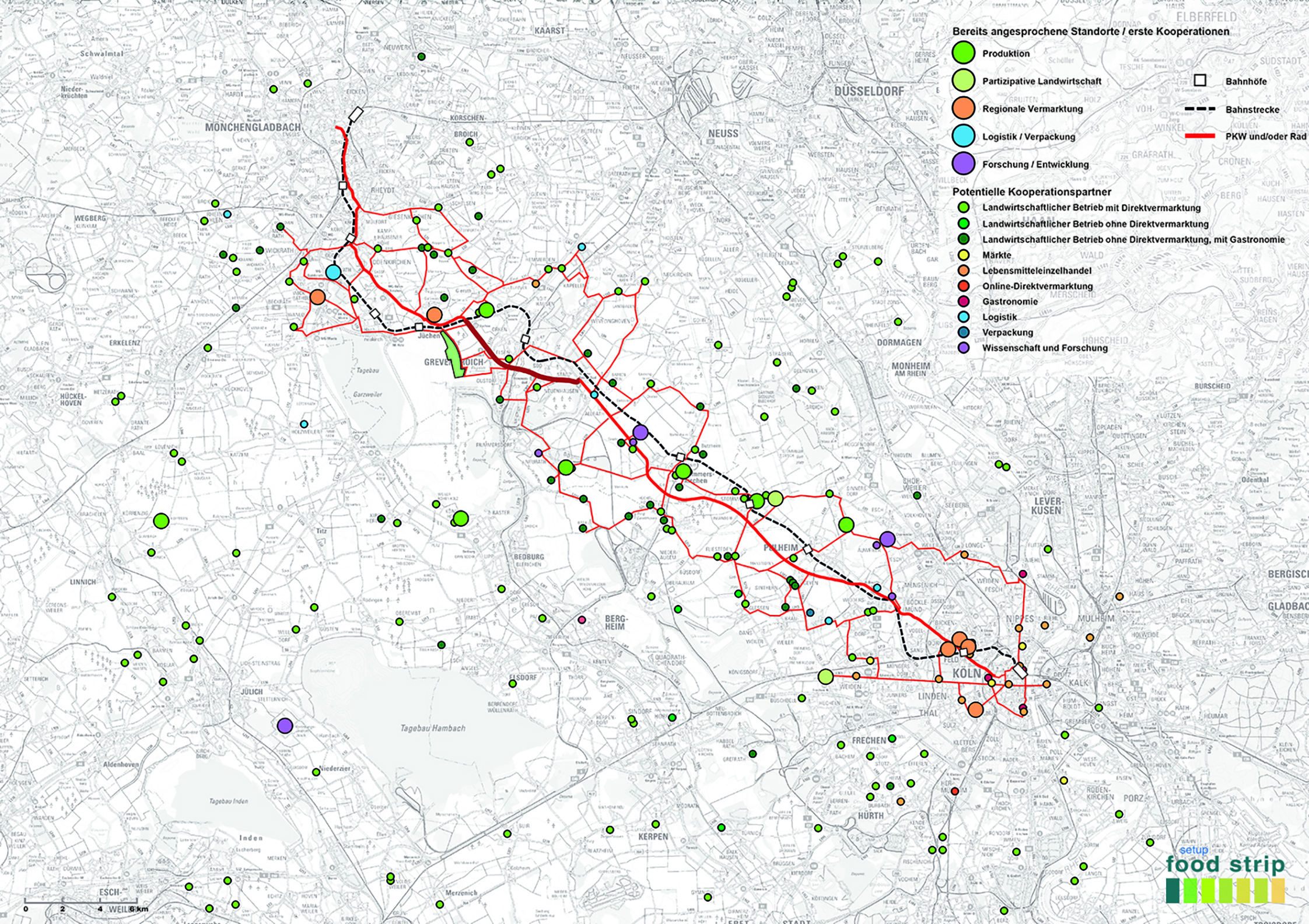
Our acting in this direction was limited to first steps. We conducted our series of interviews, performed a workshop-event for new business models with about 100 participants and a design workshop with around 20 participants. This led successfully to a range of new business models and value chains (for example tofu production from soy alternatives as grown on the Food Fields or bread based on open-source seeds). By creating a platform for communication and networking with our project, we complied with the wish of the interviewees and placed them in the center of information flow and innovation. Altogether, our actions could provide the conceptual framework for a follow up project-application within a larger network of actors (prospective start: 2023).
During these steps, we could also observe that there was a concentration of innovative actors in the peri-urban/metropolitan zone. This included the initial spatial proximity of the recultivation areas but also went well beyond. In reflection, we understand that regional design concepts towards UA like the Food Strip, in other words concepts that employ transdisciplinary or innovation-oriented stakeholder networking, show potential effectivity. They can integrate normally separated knowledge domains like agriculture and spatial design or planning in new ways. Likewise, they can link actors along the value chain that would otherwise not get in contact with each other. By boosting the exchange of knowledge regarding different needs and offers among each other, this can even lead to empowerment. A precondition for effective results, nevertheless, is the concentration of actors and locations in the respective area. As pointed out earlier, exactly this can be lacking in recultivation areas, also in times when land is given back to farmers. Hence the recultivation land’s potential role within a regional design towards UA remained indeterminable.
Food Hub
Although only mentioned as a sub-component in our initial project, we also included the idea to pursue first planning steps towards Food Hubs in the RMA. The latter generally describe local or regional food distribution centers that target institutional customers such as canteens, that can also incorporate facilities for education and leisure on site (Fischer et al. 2015; Matson and Thayer 2013). Our project’s acting strived towards reaching a minimally functional level for a first Food Hub in the RMA. For this, we started with an experimental pilot activity. The Maternushaus, the largest conference center in the Archdiocese of Cologne, was supplied by farms from the Food Strip. During one week in September 2021, guests and employees could consume dishes made from regional products as part of the campaign week.
As successful as the campaign was in the end, we observed that the logistical preparation and communication with those involved was just as intensive. At this point in time, it was only possible to meet the different needs, claims and processes with increased effort on behalf of all parties. Our test run demonstrated, that the work processes in a large kitchen cannot easily be regionalized and that the producers cannot build such supply chains on their own. This brought us back to design and evaluate two different spatial options for a food hub in a workshop session with 6 participants (Figure 5). While one option looked at an urban location and a high mix of uses (such as a market hall and a startup center), the other one was based on a peri-urban location, only making use of existing structures. While the former clearly had some advantages, a stakeholder survey after the workshop clarified that the second option was better in line with the initial idea to reach a minimum functional level first. In this light, options in the environment of the recultivation areas where suggested.
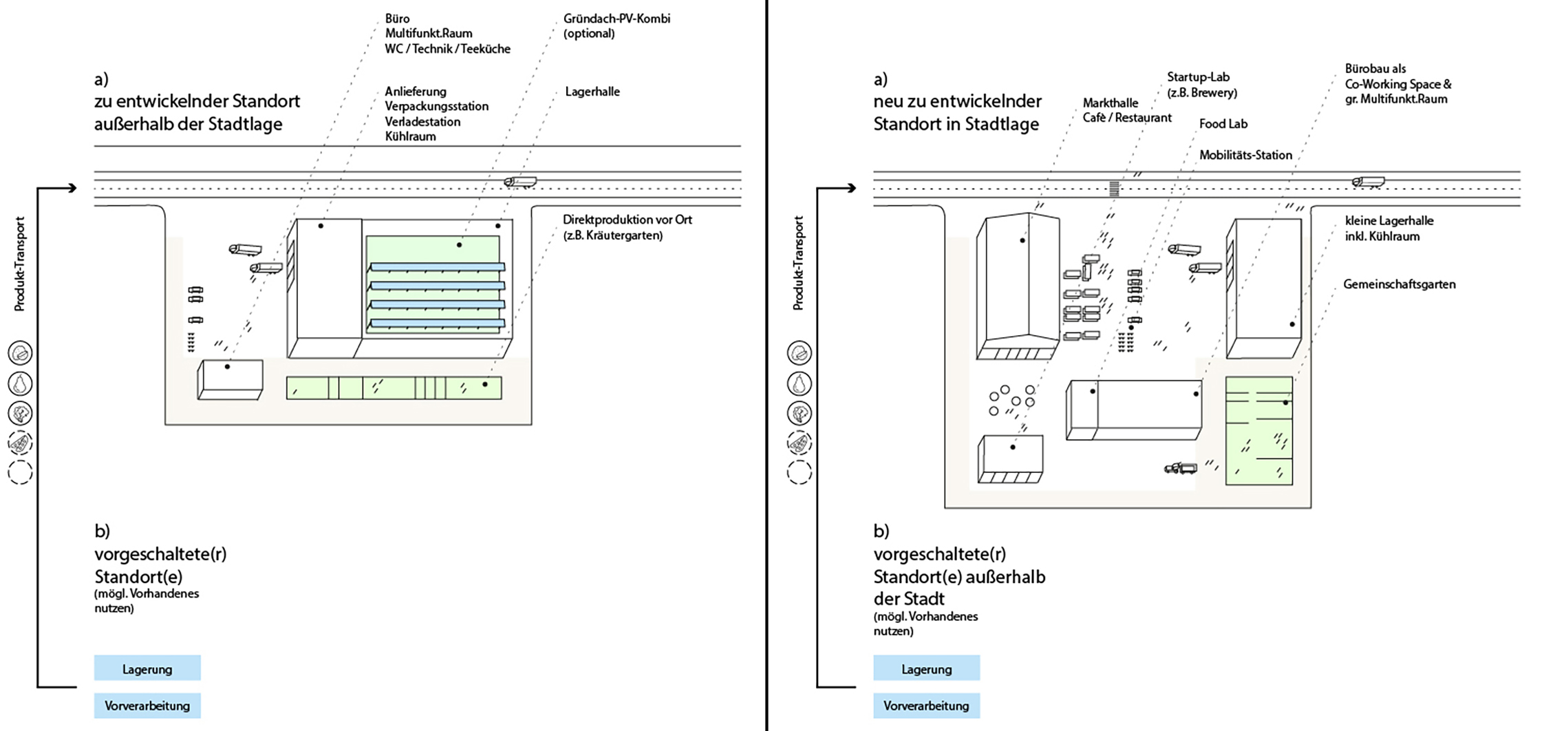
In reflection, we can conclude that regional food actors can benefit from Food Hubs as logistical nodes where different value chain participants work together based on shared information. As the RMA demonstrates, transforming mining areas can offer appropriate locations in such a context, if they are situated close, yet beyond the limits of the intensively used urban areas. The establishment of such a Food Hub however needs tremendous collaborative efforts of multiple stakeholders and local governments. Our first steps demonstrated that informal planning towards UA can initialize, accompany and moderate the setup while not carrying the responsibility alone.
Unique context, disparate value chain and the potential of design concepts
By using our project Setup Food Strip as a case study, we have generated highly context-dependent knowledge. Nevertheless, we can generalize naturally to some degree. The RMA’s spatial preconditions appear to facilitate UA strategies, which is not necessarily the case with any other mining area. The RMA with its metropolitan location represents an ideal departure point, even though regional marketing structures are yet missing. Recultivation is quite large, long-established and follows a multifunctional approach. Therefore, it can play an important role with respect to UA. Moreover, the end of mining activities will likely lead to further societal attempts to achieve a more ecological regional landscape. This will also facilitate agriculture and food production that gears at multiple local benefits such as higher biodiversity or recreational facilities. Only a potential path dependency due to a concentration on a few large-scale cash crops among farmers further away from the urban conurbations could be a certain limiting factor. Our initial question, if a post-mining situation is apt for UA, appears rather absent in academic literature. In contrast, other regional development pathways are mentioned, such as heritage preservation, recreation/tourism and renewable energy (Wirth et al. 2012; Kulik and Voigt, 2014). Even if biomass production is considered (Kretschmann 2020), it is commonly not reflected in a potential UA context.
Our stakeholder analysis revealed quite diverse perceptions among potential UA actors and various optional ways forward, rather than one. This matches with investigations regarding UA in an informal planning and governance context that have specifically highlighted the need to consider actor diversity in potential UA value chains at more depths (Giacchè et al. 2016) and even scale levels (Pettenati, 2019). While retailers in our study area were already in a process of regionalizing their businesses, farmers were facing quite existential problems such as shortage of land, water and even information and exchange. Similar thoughts considered the future. Farmers focused on changing land availabilities, while all agreed that a further regionalization of the food production and a certain qualification of the regional landscape would take place. Overall, the stakeholders appeared quite active with new cropping practices, diversification, coproduction and new regional marketing. This may not reflect the average situation in the RMA or in other mining areas, since we selected (potentially innovative) individuals known to us at least to some degree.
Overall, our three design concepts suggest potential ways forward that transcend beyond established spatial concepts in reference to UA such as urban food gardening and specialized urban farms (Lohrberg 2019) or agricultural parks (Fanfani 2019). Based on observations and reflections of our own project’s plans and actions, each of our three design concepts generated specific insights. To explore UA-compatible ways of cropping (Food Fields), recultivation lands in the making can work as show- and testing grounds. Over the long term however, other croplands may be better located in urban proximity with more innovative actors. Regional design concepts towards UA (Food Strip) can promote a better understanding of the spatial situation. Ideally, they can even boost the exchange of knowledge that is crucial for innovating value chains. However in our place-based concept, the related potential benefits and respective role of recultivation lands remains open. The latter may even offer unique locations for new logistical nodes that provide high-quality regional food to urban areas (Food Hubs). On the other hand, the necessary coordination efforts appear significant and may hint again to more urban areas. Overall, investigations on action research and design concepts are quite common in the academic realm. However, regarding spatial concepts from landscape architecture and urban design, as we have used them, more advanced methods like Research Through Design (RTD) could lead to even more focused design products. Beyond the four sections of action research, such methods can combine various criteria in order to generate more substantive knowledge (Cortesão et al. 2020). This could help to achieve the manifold societal promises assigned to UA in its academic discourse (Gottero 2019; Timpe et al. 2016).
Towards a new approach?
This article has investigated possibilities for informal planning to setup UA strategies in transforming mining areas. It thereby highlights the uniqueness of regional situation, diversity of stakeholders, and it offers three distinct spatial concepts.
Beyond the specific example of the RMA and our project, the presented approach could be promising also to other mining areas that face fundamental change. It combines agri-food and recultivation knowledge with action research, bottom-up networking and spatial designing at different scales.
Thereby it appears to generate meaningful results. Moreover, it enables recultivation practice to extend its scope and to support larger regional goals, in years or even decades before it is no longer needed. Altogether, the approach offers the chance to establish UA as a strong component within regional development pathways towards the qualification of transforming mining areas. Naturally, readers may be able to recognize similarities and differences to their own knowledge related to other regions. In this relation, further research based on cross-case analysis and generalization could be beneficial. This could refer to other examples in Germany or Europe and large lignite extraction regions in other continents worldwide.
Funding details:
The project was supported with funds from Germany’s Federal Ministry for Economic Affairs and Energy (BMWi).
References
Birley, Graham and Moreland, Neil (2014): A Practical Guide to Academic Research. Hoboken: Taylor and Francis.
Cortesão, João; Lenzholzer, Sanda; Klok, Lisette; Jacobs, Cor and Kluck, Jeroen (2020) Generating applicable urban design knowledge. In: Journal of Urban Design, 25/3, 293–307.
Creswell, John W. and Plano Clark, Vicky L. (2018): Designing and conducting mixed methods research. Los Angeles, London, New Delhi, Singapore, Washington DC, Melbourne: Sage.
Eyll-Vetter, Michael (2009): Landwirtschaftliche Rekultivierung am Beispiel des Tagebaus Garzweiler. In: Stoll, Rolf Dieter; Niemann-Delius, Christian; Drebenstedt, Carsten and Müllensiefen, Klaus (Ed.): Der Braunkohlentagebau: Bedeutung Planung Betrieb Technik Umwelt. Berlin: Springer, 511–521.
Fanfani, David (2019): Agricultural Park in Europe as Tool for Agri-Urban Policies and Design: A critical overview. In: Gottero, Enrico (Ed.): Agrourbanism. Tools for Governance and Planning of Agrarian Landscape. Turin/Cham. Springer, 149–169.
Fischer, Micaela; Pirog, Rich and Hamm, Michael W. (2015): Food Hubs: Definitions, Expectations, and Realities. In: Journal of Hunger & Environmental Nutrition 10(1), 92–99.
Förster, Agnes (2020): Regional Design: S, M, L. A Multi-level Perspective on Designing a Region. In: Lingua, Valeria and Balz, Verena (Ed.): Shaping regional futures: Designing and visioning in governance rescaling. Cham, Switzerland: Springer, 209–222.
Fürst, Dietrich (2008): Handbuch Theorien und Methoden der Raum- und Umweltplanung. 3. vollst. überarb. Aufl., Dortmund: Rohn.
Gärtner, Stefan (2014): Präventiver Strukturwandel: Strukturpolitische Möglichkeiten für die Innovationsregion Rheinisches Revier. Jülich: Study.
Gottero, Enrico (2019): Conclusion: Ten Good Reasons to Foster an Innovative Vision of Agrarian Urbanism in Europe. In: Gottero, Enrico (Ed.): Agrourbanism. Tools for Governance and Planning of Agrarian Landscape. Turin/Cham. Springer, 259–270.
Giacchè, Giulia; Ejderyan, Olivier; Cavin, Joelle S.; Lardon, Sylvie and Mumenthaler, Cyril (2016): Exploring the Diversity of Actors in Urban Agriculture. In: Lohrberg, Frank; Licka, Lilli; Scazzosi L and Timpe, Axel (eds,): Urban Agriculture Europe. Berlin. Jovis, 58–62.
Healey, Patsy (2009): In Search of the “Strategic” in Spatial Strategy Making. In: Planning Theory & Practice 10(4), 439–457.
Kempenaar, Annet and van den Brink, Adri (2018): Regional designing: A strategic design approach in landscape architecture. In: Design Studies 54, 80–95.
Kleinebeckel, Arno (1986): Unternehmen Braunkohle: Geschichte eines Rohstoffs, eines Reviers, einer Industrie im Rheinland. Köln: Greven Verlag.
Kretschmann, Jürgen (2020): Post-Mining—a Holistic Approach. In: Mining, Metallurgy & Exploration, 37, 1401–1409.
Kulik, Lars and Voigt, Jens (2014): Braunkohlenindustrie und regionale Entwicklung - Wechselwirkungen am Beispiel des Rheinischen Reviers: Braunkohlenbergbau. In: Bergbau - Zeitschrift für Rohstoffgewinnung, Energie, Umwelt (2/2014), 52–56.
Levin, Morten and Greenwood, Davydd J. (2003): Reconstructing the relationships between universities and society through action research. In: Denzin NK and Lincoln YS (eds) The Landscape of Qualitative Research: Theories and Issues. Los Angeles: Sage, 131–166.
Lohrberg, Frank; Licka, Lilli; Scazzosi L. and Timpe, Axel (2016): Urban agriculture Europe. Berlin. Jovis.
Lohrberg, Frank (2019): Urban Agriculture Forms in Europe. In: Gottero, Enrico (Ed.): Agrourbanism. Tools for Governance and Planning of Agrarian Landscape. Turin/Cham: Springer, 133–147.
LWK NRW (Ed.) (2016): Landwirtschaft im Regierungsbezirk Köln: Herausforderungen. Chancen. Perspektiven. Köln: Report.
Matson, James and Thayer, Jeremiah (2013): The Role of Food Hubs in Food Supply Chains. In: Journal of Agriculture, Food Systems, and Community Development, 1–5.
MULNV NRW (2021): Information via email, based on numbers of agricultural chamber of the federal state of North-Rhine Westphalia and Prognos.
Neuman, Michael and Zonneveld, Wil (2018): The resurgence of regional design. In: European Planning Studies 26(7), 1297–1311.
Olschowy, Gerhard (1964): Landschaftsplan Frimmersdorf-Süd (Erfttal) im Rheinischen Braunkohlengebiet. In: Schriftenreihe des Deutschen Rats für Landespflege, 2, 19–20.
Pettenati, Giacomo (2019): Urban Agriculture in Urban Food Policies: Debate and Practices. In: Gottero, Enrico (ed.): Agrourbanism. Tools for Governance and Planning of Agrarian Landscape. Turin/Cham. Springer, 171–185.
Pflug, Wolfram F. W. (Ed) (1998): Braunkohlentagebau und Rekultivierung: Landschaftsökologie - Folgenutzung - Naturschutz. Berlin, Heidelberg: Springer.
Plano Clark, Vicki L. and Ivankova, Nataliya V. (2016): Mixed methods research: A guide to the field. Los Angeles: Sage.
Schuhmacher, Achim; Dworschak, Ulf and Weglau, Jochen (2011): Rekultivierung im Rheinischen Braunkohlenrevier: Exkursionsführer Teil 2.
Simons, Helen (2009): Case study research in practice. In: van Veenhuizen, René (2006): Cities farming for the future: Urban agriculture for green and productive cities. Silang, Philippines, s.l., Ottawa: RUAF Foundation.
Timpe, Axel; Cieszewska, Agata; Supuka, Jan and Tóth, Attila (2016): Urban Agriculture Goes Green Infrastructure. In: Lohrberg, Frank; Licka, Lilli; Scazzosi L and Timpe, Axel (Ed.): Urban Agriculture Europe. Berlin: Jovis, 126–137.
Wirth, Peter; Cernic Mali, Barbara and Fischer, Wolfgang (2012): Post-Mining Regions in Central Europe. Problems, Potentials, Possibilities. München: Oekom Verlag.
Wirth, Timo M. (2019a): Proaktive Transformation durch Regionales Strategie-Entwerfen. Dissertation/PhD at RWTH Aachen University. Aachen.
Wirth, Timo M. (2019b): Vom Braunkohlerevier zum „Zukunftsrevier“: Werkstattbericht zur Transformation einer Zwischenregion (Rheinisches Revier). In: PLANERIN 3/19, 24–26.
Wirth, Timo M. (2019c): Website, Project „Setup Food Strip“. www.foodstrip.eu, accessed 16.02.2023.
Yin, Robert K. (2013): Case Study Research: Design and methods. Newbury Park: SAGE.